


South Bay Regional Public Communications Authority
South Bay Regional Public Communications Authority Achieves Multi-Agency Interoperability Using Sierra Wireless® AirLink® Mobile Gateways

South Bay Regional Public Communications Authority Achieves Multi-Agency Interoperability Using Sierra Wireless® AirLink® Mobile Gateways
A Sierra Wireless Mobile Workforce Solution
CUSTOMER CRITICAL CHALLENGE
SOLUTION
BENEFITS
The SBRPCA is currently owned by the Cities of Gardena, Hawthorne and Manhattan Beach while also providing communications services to the cities of El Segundoand Hermosa Beach under contract. Police officers and fire fighters from the member cities make up the Police and Fire Task Forces, which provide feedback andrecommendations to facilitate an optimum level of service and safety for citizens, police officers and firefighters.
Business Challenge
SBRPCA faces a tough challenge in daily operations, as joint dispatching of multiple agencies requires well-coordinated efforts among participants to support regionaloperations. Even a routine calls dynamic may change and require immediate responses from multiple agencies.
A reliable common operating picture is the key to effective response. Watch commanders and dispatchers must be able to view all current incidents and available city resources in the region, as well as availableunits from neighboring cities. A dispatcher must be able to quickly and accurately locate available units closest to each incident. To SBRPCA, the challenge is even more complicated, as each agency dispatcher must also be able to identify the closest units from neighboring agencies whenever the need for mutual aid arises.
Field officers from multiple agencies face similar challenges. In order to safely and efficiently respond to an incident, field officers need continuous access to incident location data and a common operating picture across all agencies. Achieving this requires the availability of real-time information from Geographic Information Systems (GIS) not just citywide, but across an entire region.
To manage multi-agency dispatching and field response effectively, watch commanders, dispatchers, and field service officers require the latest technology inwireless communications, GPS, and mobile mapping to maintain the highest level of situational awareness.
Sierra Wireless AirLink Solution
SBRPCA contracted Sierra Wireless Solution Partner GeoSpatial Technologies, Inc. (GST) to implement a system built on the cutting-edge technologies in wirelesscommunications, real-time tracking, and mobile mapping to answer the challenges of its complex situation. For a reliable link between regional dispatch services and theirfield officers, GSTs solution relies on the Sierra Wireless AirLink of mobile gateways to deliver high performance, mission-critical cellular communication and GPS capabilities.
We have worked with AirLink gateways for about a decade, so we knew we had a robust device that delivered the GPS capabilities and cellular communications that we needed.The manageability of the gateways is also an important ingredient, and the available firmware template settings made configuration easy, said Wilbur Hu, VP of Operations atGST, which completed all hardware and software setup and validation before delivering the devices to SBRPCA for in-vehicle installation. As a member of the Sierra WirelessSolution Partner Program, we are able to have close interaction with the Sierra Wireless team to help ensure that our solution is tightly integrated with their hardware andsoftware. We see tremendous value in being part of their industry leading program.
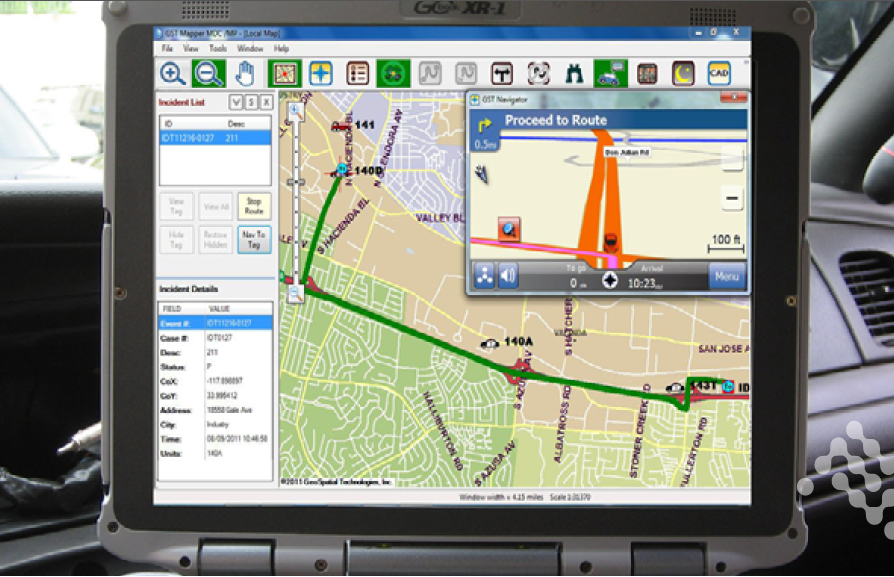
The GST system incorporates a live interface between GST and SBRPCAs Computer- Aided Dispatch (CAD), which enables delivery of critical incident information directly toa field officers in-vehicle Mobile Data Computer (MDC). Due to bandwidth constraints in a mobile environment, Automatic Vehicle Location (AVL) data must be dynamicallyfiltered based on geography in order to deliver only the necessary information to each unit within a certain incident areaa feature supported by the AirLink mobilegatewayswhile the officers are on the move. Whenever a call is received, the officer uses the mapping software on his/her MDC to see the incident, the GPS position of thevehicle, and the fastest route to that incident. The officer can also see the whereabouts of other units of the city, as well as nearby units from neighboring agencies.
Results
Since the successful deployment of the GST system, SBRPCA has reported reliable and effective wireless communication. The system has improved situational awarenessin regional, multi-agency inter-operations, as well as provided an added boost to field officer safety.
What started as a single police department effort has expanded to multiple police departments and other city agencies, including fire departments and community colleges.
In an era of shrinking budgets and increased challenges providing police services, the need to partner and work closely with surrounding cities is more important thanever before, said Captain Michael Ishii, Hawthorne Police Department. As each department participates in regional taskforces and supports one another during major incidents, the ability to view, coordinate, and manage multiple units from different jurisdictions on one map becomes a valuable resource for the Incident Commander of a major operation, while enhancing officer safety.
A Sierra Wireless Mobile Workforce Solution
CUSTOMER CRITICAL CHALLENGE
- In-vehicle communications solution for multi-agency initiative
- Persistent, secure wireless communications, GPS capabilities, and rugged design for in-vehicle environmental conditions
SOLUTION
- AirLink® mobile gateways provides reliable, secure cellular communications, GPS services, and a military spec design for mobile and industrial applications
BENEFITS
- Secure, reliable connectivity for access to critical location and situational awareness data
- Reliable GPS with advanced features such as dynamic filtering
- Rugged design for in-vehicle and industrial environments
- Easy configuration and management of multiple devices
The SBRPCA is currently owned by the Cities of Gardena, Hawthorne and Manhattan Beach while also providing communications services to the cities of El Segundoand Hermosa Beach under contract. Police officers and fire fighters from the member cities make up the Police and Fire Task Forces, which provide feedback andrecommendations to facilitate an optimum level of service and safety for citizens, police officers and firefighters.
Business Challenge
SBRPCA faces a tough challenge in daily operations, as joint dispatching of multiple agencies requires well-coordinated efforts among participants to support regionaloperations. Even a routine calls dynamic may change and require immediate responses from multiple agencies.
A reliable common operating picture is the key to effective response. Watch commanders and dispatchers must be able to view all current incidents and available city resources in the region, as well as availableunits from neighboring cities. A dispatcher must be able to quickly and accurately locate available units closest to each incident. To SBRPCA, the challenge is even more complicated, as each agency dispatcher must also be able to identify the closest units from neighboring agencies whenever the need for mutual aid arises.
Field officers from multiple agencies face similar challenges. In order to safely and efficiently respond to an incident, field officers need continuous access to incident location data and a common operating picture across all agencies. Achieving this requires the availability of real-time information from Geographic Information Systems (GIS) not just citywide, but across an entire region.
To manage multi-agency dispatching and field response effectively, watch commanders, dispatchers, and field service officers require the latest technology inwireless communications, GPS, and mobile mapping to maintain the highest level of situational awareness.
Sierra Wireless AirLink Solution
SBRPCA contracted Sierra Wireless Solution Partner GeoSpatial Technologies, Inc. (GST) to implement a system built on the cutting-edge technologies in wirelesscommunications, real-time tracking, and mobile mapping to answer the challenges of its complex situation. For a reliable link between regional dispatch services and theirfield officers, GSTs solution relies on the Sierra Wireless AirLink of mobile gateways to deliver high performance, mission-critical cellular communication and GPS capabilities.
We have worked with AirLink gateways for about a decade, so we knew we had a robust device that delivered the GPS capabilities and cellular communications that we needed.The manageability of the gateways is also an important ingredient, and the available firmware template settings made configuration easy, said Wilbur Hu, VP of Operations atGST, which completed all hardware and software setup and validation before delivering the devices to SBRPCA for in-vehicle installation. As a member of the Sierra WirelessSolution Partner Program, we are able to have close interaction with the Sierra Wireless team to help ensure that our solution is tightly integrated with their hardware andsoftware. We see tremendous value in being part of their industry leading program.
The GST system incorporates a live interface between GST and SBRPCAs Computer- Aided Dispatch (CAD), which enables delivery of critical incident information directly toa field officers in-vehicle Mobile Data Computer (MDC). Due to bandwidth constraints in a mobile environment, Automatic Vehicle Location (AVL) data must be dynamicallyfiltered based on geography in order to deliver only the necessary information to each unit within a certain incident areaa feature supported by the AirLink mobilegatewayswhile the officers are on the move. Whenever a call is received, the officer uses the mapping software on his/her MDC to see the incident, the GPS position of thevehicle, and the fastest route to that incident. The officer can also see the whereabouts of other units of the city, as well as nearby units from neighboring agencies.
Results
Since the successful deployment of the GST system, SBRPCA has reported reliable and effective wireless communication. The system has improved situational awarenessin regional, multi-agency inter-operations, as well as provided an added boost to field officer safety.
What started as a single police department effort has expanded to multiple police departments and other city agencies, including fire departments and community colleges.
In an era of shrinking budgets and increased challenges providing police services, the need to partner and work closely with surrounding cities is more important thanever before, said Captain Michael Ishii, Hawthorne Police Department. As each department participates in regional taskforces and supports one another during major incidents, the ability to view, coordinate, and manage multiple units from different jurisdictions on one map becomes a valuable resource for the Incident Commander of a major operation, while enhancing officer safety.